Today, The Open Source Geospatial Foundation celebrates our 11th Anniversary. On behalf of the Open Source Geospatial Foundation i would like to send our greetings to everyone on the happy occassion of 11th Anniversary of when our Foundation was founded (4th Feb 2006) at http://www.osgeo.org/node/1672
It is my great pleasure, to introduce our colleagues at the Open Source Geospatial Lab of The Department of Geodesy and Geoinformatics of the Faculty of Civil Engineering, University of Belgrade as our “GeoForAll” lab of the month. The Department of Geodesy and Geoinformatics of the Faculty of Civil Engineering, University of Belgrade has been actively using open source software in education of geodetic engineers at the undergraduate, graduate and PhD studies. A large number of bachelor’s, master’s and doctoral thesis has been created using open source software. Additionally, a significant number of scientific papers written by members of the department has also been published using open source software. The development of Laboratory for development of open source geospatial technologies – OSGL Belgrade at the Department of Geodesy and Geoinformatics seemed like the logical next step in the process of promotion and cultivation of a open source approach to the improvement of teaching and research at the University of Belgrade. In addition to intensive use of open source in BSc and MSc courses, there is an example of contribution to open source community from Luka Glušica, an OSGL Belgrade member and master student of the Geoinformatics module at the Department of Geodesy and Geoinformatics who has got Google Summer of Code scholarship. Luka is currently working on his master thesis in the field of Information Technologies in Cartography at OSGL Belgrade, under the mentorship of Dr. Milan Kilibarda. Luka works on development of JavaScript framework that will allow developers to easily implement istSOS functionality in existing or new web application. (details: https://webpractice-lukag.github.io/istSOS-Web-API/)
In addition to their teaching obligations, members of OSGL lab are also involved in international and national scientific and innovation projects. One of the ongoing projects is APOLLO, the EU-funded HORIZON 2020 project aiming to develop a market-ready platform of agricultural advisory services for primarily, but not exclusively, at smallholder farmers in Europe. The APOLLO project aims to bring benefits of precision agriculture to farmers through affordable information services, making extensive use of free and open Earth Observation data, such as those provided by the European Union’s Copernicus programme. These services will help farmers to make better decisions by monitoring growth and health of crops, providing advice on when to irrigate and till their fields, and estimating the yields. Ultimately, these interventions should lead to decreased costs and higher yields – and therefore increased profitability and competitiveness. (http://apollo-h2020.eu/)
Recently completed Serbian research data portal which was developed under Danube Data and Services Infrastructure (DRDSI) project was also made at OSGL Belgrade using open source Geonetwork (http://osgl.grf.bg.ac.rs/en/services/geonetwork/). “The purpose of the work within the Serbian research data portal is to establish a ‘local node’ for the DRDSI in Serbia and to explore how this approach could be adopted by key actors in the country. This work created a ready and sustained means to harvest metadata using an Open Data approach, based on the technologies used by the DRDSI platform. In addition, it acts as a demonstrator for other organisations to share data by documenting the approach and experience gained, creating further content for the DRDSI Platform.” (from: Data Infrastructures in Support of Macro-Regional Development. Experiences and Lessons Learned from the Danube Region; EUR 28297 EN; doi:10.2791/42047 )
Many workshops and conferences were organised by OSGL Belgrade. Some examples below
GeoMLA: Geostatistics and Machine Learning Applications in Climate and Environmental Sciences; (http://geomla.grf.bg.ac.rs/)
WorldDailyMeteo: space-time interpolation of daily meteorological variables at 1 km resolution;(http://dailymeteo.org/2014), folowed by Special issue in Spatial Statistics
Spatial and spatio-temporal modeling of meteorological and climatic variables using Open Source software (http://www.sciencedirect.com/science/article/pii/S2211675315000536)
R+OSGeo in higher education (http://geostat-course.org/R_OSGeo_in_Education_Belgrade)
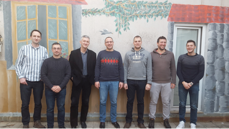
OSGL Belgrade core team from left: Nemanja Branisavljevic, Dragutin Protic, Branislav Bajat, Milan KIlibarda, Ognjen Antonijevic, Luka Glusica, Aleksandar Sekulic
The GeoForAll lab in University of Belgrade welcomes collaborations from all interested and for making contributions to the wider society. More details at http://osgl.grf.bg.ac.rs/en/
On behalf of the GeoForAll community, we thank Dr. Milan KIlibarda and all colleagues from the University of Belgrade and for their contributions to the GeoForAll initiative and look forward to working and building more collaborations with all interested on this education mission.
Happy birthday to OSGeo Foundation and may God’s grace and blessings be with all of us and OSGeo for our efforts to empower everyone with open geo principles to help create a world that is more accessible, equitable and full of innovation and opportunities for everyone.
Best wishes,
Suchith Anand
http://www.geoforall.org/