Tell World Leaders: We Must Unlock the Data Needed to Feed the Hungry

Nearly 800 million people struggle with hunger worldwide. We have the knowledge, the tools and the data to lower this figure to 0 – but this can only happen if everyone has equal access to data. Access to research and data is crucial to feeding the world’s hungry. World leaders and the brightest minds in agriculture and data are currently in New York for the GODAN Summit 2016 to make agricultural and nutrition data free for farmers around the world.

screen-shot-2016-09-15-at-10-03-28
The largest-ever event dedicated to open data and agriculture, the GODAN summit will take place on the margins of the UN General Assembly in New York. The aim will be to urge world leaders to open their national datasets on agriculture and nutrition to help bring hunger around the world to an end. Experts from around the world have gathered to discuss opening vital data on agriculture and nutrition to millions who don’t have access. We are convinced that the solution to eliminating hunger lies within existing, but often unavailable, agriculture and nutrition data.


The Global Open Data for Agriculture and Nutrition (GODAN) initiative is committed to closing this unacceptable hunger gap by making agriculture and nutrition data available, accessible and useable to everyone. Portions of the event will be LIVE webcast.  So those interested can watch . Details are at the GODAN Summit 2016 website 
http://summit.godan.info      Videos from the event will be posted on the GODAN YouTube Channel.


The Global Open Data for Agriculture and Nutrition (GODAN) 
http://www.godan.info    initiative was announced in 2013 and aims to bring countries together to harness the massive amounts of data to solve hunger problems, benefit farmers, and address consumer health issues. GODAN seeks to support global efforts to make agricultural and nutritionally relevant data available, accessible, and usable for unrestricted use worldwide. By empowering stakeholders and world leaders to enable action, GODAN works to unlock the data necessary to solve the challenge of global food insecurity.


We need your help to help farmers get the data they need and help end hunger. We call on you to support this global action to get every government, non­-governmental, international and private sector organization to make agriculture and nutrition data available, accessible and usable.


Make your voice heard at 
http://summit.godan.info/petition 

I will be sharing Geo4All ideas on the importance of Openness in research at the GODAN Summit  tomorrow (16 Sep at 1:30 pm local time). Details at http://summit.godan.info/schedule 

We look forward to your active support.

Best wishes,


Suchith


Dr. Suchith Anand

http://www.geoforall.org 

Geo for All – Building and expanding Open Geospatial Science

Kalpana Chawla Chair on Geospatial Technology and our new OSGeo lab at PEC University of Technology, Chandigarh, India

It is my great pleasure to welcome PEC University of Technology, Chandigarh, India http://www.pec.ac.in/ as our new OSGeo lab. PEC University of Technology, formerly known as Punjab Engineering College, is an engineering institute located in the city of Chandigarh, India. Founded in 1921, it is one of the oldest educational institutes in India.I also really like the motto of PEC  (Tamaso Ma Jyotirgamaya) which in Sanskrit the meaning of which is “From darkness (of ignorance) lead us to Light (of Knowledge)”

Prof. Manoj Arora who is heading  as Director (Vice Chancellor), PEC University of Technology Chandigarh and Professor of Civil Engineering, IIT Roorkee (on lien)  where he is working as Professor in Remote Sensing in the department of Civil Engineering is the main force behind the establishment of OSGeo lab at PEC. He has also shared the good news that they now have partnered with Indian Railways to establish Kalpana Chawla Chair on Geospatial Technology at PEC.

kalpana


Kalpana Chawla [1] was an Indo-American astronaut and the first woman of Indian origin in space. She first flew on Space Shuttle Columbia in 1997 as a mission specialist and primary robotic arm operator. In 2003, Chawla was one of the seven crew members killed in the Space Shuttle Columbia disaster. She was a true global citizen working for the advancement of science for all, so it is fitting tribute that through PEC , one of our OSGeo labs will have chair in geospatial technologies established in her honour. I thank Dr Manoj Arora  and other colleagues who have worked hard to make this possible and Indian Railways for funding this chair.

Manoj has visited Nottingham University twice in recent time (though i couldnt meet him!) (June and Sept 2014 for a day each) as part of delegation from Chandigarh Region Innovation and Knowledge Cluster (CRIKC)  http://crikc.puchd.ac.in     .  CRIKC is a cluster of 15 odd academic institutions and research institutions in Chandigarh with Vice Chancellor, Panjab University, as the Chairman. CRIKC has signed MoU with University of Nottingham to have academic collaboration in many different ways. I can see many research synergies in open geospatial esp. in Opencitysmart research that we will be able to able to explore in the future.

Best wishes,

Suchith Anand
http://www.geoforall.org/

[1] https://en.wikipedia.org/wiki/Kalpana_Chawla

Open Principles in Education – Building Bridges, Empowering communities

Dear colleague,

I have been invited to deliver a webinar by the Open Education community on 22 September, 2016 at 12.30PM – 1.30PM (UK time) and i would like to invite all interested to join.

I will use this opportunity to share our Geo4All experiences with the wider education community and build more synergies. Over 20 years back , i was a student in Civil Engineering in India and by pure chance i came across a short article in a magazine in my college library on the amazing Geographic Information System that is used by Town Planners . That was the first time i heard about the wonderful technology called GIS!  That time, there was no GIS where i studied but i was determined to get access to learn GIS . I still remember the struggles i went through to get access to GIS that time in India as there were very few universities who had GIS those days.  I was very lucky as by God’s grace i got some amazing opportunities later to learn GIS. So now it is my duty that others also get opportunity to learn GIS .

So through this webinar , i want to share why it is important that we protect Open principles in Education and the vision 2030 for Open Geospatial Science  [1][2] . This presentation will share experiences from “Geo for All” initiative on the importance of having open principles in education for empowering communities worldwide . Central to “Geo for All” mission is the belief that knowledge is a public good and Open Principles in Education will provide great opportunities for everyone. Though the members of our community hail from many different backgrounds, we all seek to eliminate the digital divide and empower all as full citizens and contribute to building up Open Knowledge for the benefit of the whole society . By combining the potential of free and open  software, open data, open standards, open access to research publications, open education resources in Geospatial education and research will enable the creation of sustainable innovation ecosystem . This is key for widening  education opportunities, accelerating new discoveries and helping solving global cross disciplinary societal challenges from Climate change mitigation to sustainable cities. Service for the benefit and betterment of humanity is a key fundamental principle of “Geo for All” and we want to contribute and focus our efforts for the United Nations Sustainable Development Goals. We aim to create openness in Geo Education for developing creative and open minds in students which is critical for building open innovation and contributes to building up Open Knowledge for the benefit of the whole society and for our future generations. The bigger aim is to advance STEM education across the world and bring together schools, teachers and students across the world in joint projects and help building international understanding and global peace. More details at  http://www.geoforall.org/

Webinar details at https://www.alt.ac.uk/civicrm/event/info?reset=1&id=249

Screen Shot 2016-07-11 at 13.18.25

We do not have the money /sponsorship power as some vendors but we do have amazing people power like you all  globally to make things happen. I thank you for your help in sharing Geo4All ideas. Ideas that  starts from nothing are very powerful and keeps expanding exponentially .

Screen Shot 2016-07-02 at 05.56.42

Best wishes,

Suchith Anand

http://www.geoforall.org/

Geo for All – Building and expanding Open Geospatial Science

[1] http://www.geoconnexion.com/uploads/publication_pdfs/uk_v15i18-058-059-Op951AF3.pdf
[2] http://www.geoconnexion.com/publications/geo-uk/issue/sept-oct-2016/article/open-geospatial-science-and-vision-2030

Open Geospatial Science and Vision 2030

Next week, we have two meetings planned in the USA (one in Denver and one in New Mexico) where there is further opportunities to expand the discussions and ideas on Open Geospatial Science – Vision 2030 [1] and how we can build synergies towards the vision of the UN 2030 Agenda for Sustainable Development for building a better world for all.
Screen Shot 2016-09-07 at 13.02.19
Advancing GIScience with Open Source Technologies meetings are organised by the ICA Commission on Open Source Geospatial Technologies at AutoCarto 2016, USA Details at  http://www.unm.edu/~sfreunds/autocarto2016/Open_Source_Geospatial.html  Thanks to Mike Finn and Silvana Comboim for their leadership
Geospatial IG of the Research Data Alliance will meet in Denver later that week . It will also be an opportunity to expand ideas/discussions on this
Looking forward to working with you all on this.
Best wishes,
Suchith Anand

GeoAmbassador of the month – Nimalika Fernando

Dear colleagues,

It is my great pleasure to introduce Nimalika Fernando as our GeoAmbassador. I am grateful for this opportunity of introducing some of our amazing colleagues from different parts of our world each month as our GeoAmbassadors and this has also helped me also to learn and get inspired by their amazing work and contributions for the wider community. Nimalika established the OSGeo lab at Sri Lanka Institute of Information Technology(SLIIT), Sri Lanka in 2014. Though I have not yet got the opportunity to meet Nimalika , I am amazed by her teaching and contributions she made.

Nimalika_SLIITPhoto


Nimalika Fernando was an academic attached to Sri Lanka Institute of Information Technology(SLIIT), Sri Lanka from 2001 -2016 and now she is a research student at Curtin University, Perth Australia. Nimalika has moved to geospatial domain in 2005 with her MSc project, without having any formal education in GIS . GIS became practically important to the country at that time as Sri Lanka was facing large planning issues after 2004 Tsunami with no much technological knowledge at hand. Dr. Waidyasekara, a GIS enthusiastic who was a senior academic at SLIIT that time proposed a web GIS for post disaster recovery management but the concept and technologies were entirely new to the country. Nimalika happened to inquire about free and open source approaches and MapServer and PostGIS as tools were the starting point of her GIS journey to learn web GIS. Her link with FOSS GIS continued ever since and she had started teaching what she had learned by experience and advocating the value of open source GIS to Sri Lankan community.

She designed and delivered a module on web –GIS with Map Server in 2008 for postgraduate students at Postgraduate Institute of science , Peradeniya by invitation of the MSc course coordinator, Dr. Jagath Goonathilake , who had taken a very challenging decision that time to introduce open source GIS to his students , in a background where nobody have heard about such options available. This module has opened Sri Lankan GIS professionals to open source GIS, a very new domain in Sri Lanka then and now it has become an established module where she still continue to be a teaching panel member.

In 2009, she introduced a “Geographic Information Systems” module as an elective to undergraduate students of Faculty of IT, University of Moratuwa. The same module was introduced to Faculty of Computing, SLIIT in 2011 with more practical components. Both these modules provide a unique opportunity to Sri Lankan undergraduates having IT background to learn and experience geospatial domain.

In 2014, the first Sri Lankan free and open source community gathering, FOSS4G Sri Lanka 2014 was organized by Nimalika and her team (Dr. Yann, Aruna of UOM and FOSS community of SLIIT) which brings together GIS enthusiasts of Sri Lanka ,including some very new to FOSS GIS. (http://foss4gsrilanka.lk/ )

She has being mentoring and conducting guest lectures and seminars on open source GIS for Sri Lankan university students and public servants travelling around the country. She teaches tools such as MapServer, QGIS , PostGIS and OSM mapping to Sri Lankan community. She has being participating at GIS events worldwide and was presenting at FOSS4G 2009 Sydney, FOSS4G Asis 2014 Bangkok and FOSS4G 2015 Seoul. She assisted in organizing FOSS4G Asia 2014 Bangkok and Asia Special Track of FOSS4G 2015 Seoul.

At SLIIT she acted as the advisor of Rotaract Club of SLIIT, FOSS Community of SLIIT , leader of the Geoinformatics & LBS research group and acted as a student counsellor from 2012 onwards.

Her biography is at https://lk.linkedin.com/in/nimalika-fernando-53b82813

Nimalika also kindly send updates on OSGeo Lab of SLIIT which is summarized below

In February 2014, OSGeo lab of SLIIT was initiated as the second OSGeo lab of Sri Lanka with Nimalika as the contact point. (http://lists.osgeo.org/pipermail/announce/2014-February/000249.html)

It was Dr. Yann Chamin who motivated to initiate the lab, who was introduced to Nimalika by Vivien Deparday, a keen GIS developer who regularly visit Sri Lanka and always keen in linking Sri Lankan community with the world community. The lab marked a milestone for GIS teaching and learning of SLIIT students and the whole community.

Some remarks of the OSGeo lab of SLIIT and outcomes

  • An elective module , GIS is offered to SLIIT final year IT students via the lab , which became a very successful module where students are introduced to GIS concepts and tools. Many of them use the skills in their final year projects and professional life.
  • Lab act as a contact point for other Sri Lankan universities and community to get support and resources
  • OSGeo lab of SLIIT acted as the core organizer, providing venue and all logistics support for FOSS4G Sri Lanka 2014
  • A team of SLIIT students has won the best student presentation at the FOSS 4G 2016, Seoul for their presentation “Landmark Based Path Planning and Linear Path Generation for Mobile Map Applications.” ( News Article : http://www.directionsmag.com/entry/reflections-on-foss4g-seoul-2015/455554 )

They were trying to apply the local and personal context to land mark based path planning and developed a novel method for path planning using a weighted model. OSM data were used for the application.

Screen Shot 2016-09-05 at 14.58.54


SLIIT Students Pasundu Chandrasekara & Thejaka Mahaulpatha receiving the award at FOSS4G 2015 

  • OSGeo Lab of SLIIT links students to industry opportunities. Until now two students of SLIIT had obtained valuable internships for GIS Programming in World Bank projects in Sri Lanka. The experience they obtain via this would be remarkable as they work directly under the supervision of core developers from the team. They work related to GeoNode based application development.

 Some activities organized by the lab

  • We organized seminars to introduce new technologies and to link students ( Open data for resilience -2014, Geo-social Intelligence to aid Disaster Response -2015)
  • A workshop to celebrate the world geography awareness week is organized by the lab in 19th November 2016, linking with OSM Geography awareness week.

Poster  used for OSM workshop

Screen Shot 2016-09-05 at 14.59.07 

 Screen Shot 2016-09-05 at 14.59.17

Photos from the OSM Workshop

 Screen Shot 2016-09-05 at 14.59.28

Photos from the OSM workshop : Mr. Sudakarna fom GFDRR Project assisted as a resource person


  • As an immediate response to heavy floods occurred in Sri Lanka in May 2016, Humanitarian OpenStreetMap Team (HOT) organized global mapping events to map flood affected areas. SLIIT OSGeo lab also took part of this and organized a Mapathon to support flood on 21st of May 2016. This was a unique event, organized within a day while the university is blocked by floods.

 Screen Shot 2016-09-05 at 14.59.45

A photo from the Flood mapping event


( Link can be found here : https://www.mapbox.com/blog/relationships-tools-response/ )

Geo for All is a worldwide movement that provides immediate benefit to the world. We aim to create openness in Geo Education for developing creative and open minds in students which is critical for building open innovation and contributes to building up Open Knowledge for the benefit of the whole society and for our future generations. We are proud to honour Nimalika as our GeoAmbassador and we are extremely grateful for her contributions to Geo for All.

Best wishes,

Suchith Anand


Geo4All – Empowering academics and educators globally – requesting colleagues to share Geo4All ideas at all Geography events

Dear colleague,

20 years back many academics and educators (esp. in  developing countries) struggled to start GIS courses for thier students and had to beg to vendors for some “free” licences .Now they dont need any “charity” from any vendors, as they are fully empowered and can start courses as they wish without any permissions from any vendor owners . We want academics globally to be fully empowered  from now and   give software as they wish to thier students education. By  making free and open software and educational resources available for all has empowered academics and educators globally and brought down the “Iron Curtains” that  some  vendors have tried to create in education. Now no vendors  can dictate terms to any academic or educator or student. We want academics to be in full control of education from now not any vendors.

I would like to thank the OSGeo Live community for making available Version 10.0 of the OSGeo-Live GIS software collection that has been released at FOSS4G conference in Bonn, Germany – the annual global event of the Open Source Geospatial Foundation (OSGeo).

OSGeo Live  is an excellent resource for academics and educators around the world to teach geospatial science and give away the software for free to thier students thereby empowering them in the true sense. This  excellent resource is made  available to the global community thanks to the hardwork and selfless dedication of hundreds of  volunteers (Developers, packagers, documenters and translators) in addition to thousands who have been involved in building the packaged software. Thank you all for making this possible.

osgeolive10

OSGeo-Live is a self-contained bootable DVD, USB flash drive and Virtual Machine, pre-installed with robust open source geospatial software, which can be trialled without installing anything.

OSGeo Live  includes:

*       Over 50 quality geospatial Open Source applications installed and pre-configured
*       Free world maps and sample datasets
*       Project Overview and step-by-step Quickstart for each application
*       Lightning presentation of all applications, along with speaker’s script
*       Translations to multiple languages

Details at  http://live.osgeo.org

Download details at  http://live.osgeo.org/en/download.html

Contents overview at https://live.osgeo.org/en/overview/overview.html

I request all colleagues globally to make use of opportunities like Geography Awareness Week (November 13 – 19, 2016) and other important Geography events  like OSM Week 2016, GIS Day 2016    etc to spread Geo4All ideas and give away OSGeo Live DVD, USB   to your colleagues and  students so they dont have to buy any properitery GIS software and truly empowering them. By doing so, you are  gifting millions of dollars of software to your students (if i may borrow some ideas from our properitery friends!  🙂 So go ahead and gift software for free from now at all  Geography Awareness Week and all other key GIS events… We want all academics from now be the owners of the software and tools . You dont have to get permission from any properitery GIS vendor owners to start your courses or gift software to your students!

Geo4All is and will be always open to all projects and initiatives that support Open Principles in Education. We have a duty and long term view on Open Principles in education to ensure that free and open geospatial education opportunities  are available not just to current generation but also to our future generations…

Best wishes,

Suchith

Dr. Suchith Anand
http://www.geoforall.org/

Geo for All – Building and expanding Open Geospatial Science

“Geo4All” Lab of the Month –University of Zagreb, Croatia

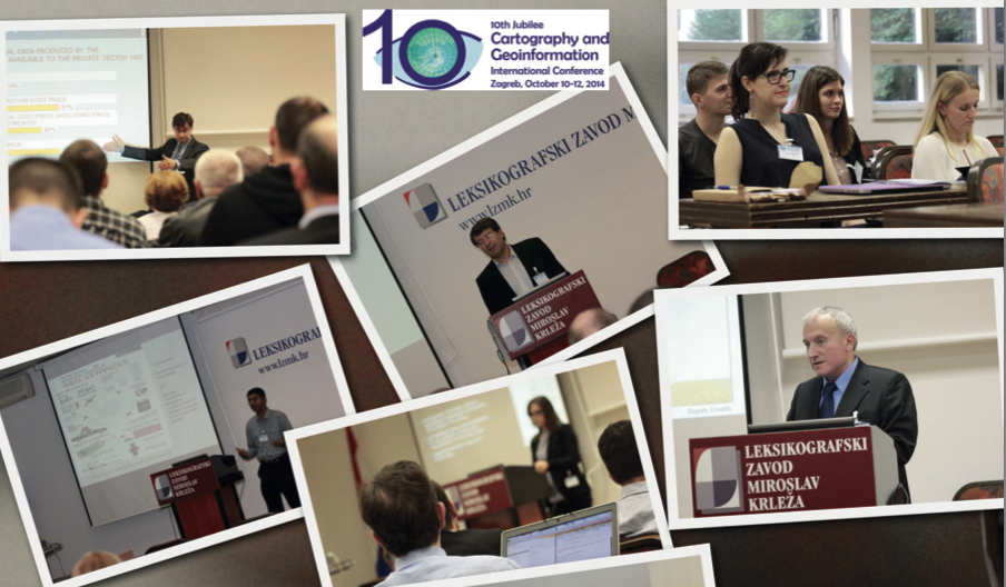
It is my great pleasure to introduce our colleagues at OSGL of the Faculty of Geodesy, University of Zagreb, Croatia as our “Geo4All” lab of the month. I thank Dražen Tutić for providing all the background information and photos of the activities of the lab which is summarized in this article. I first met Dražen Tutić , Miljenko Lapaine and other colleagues when I visited Zagreb for the 10th Jubilee  Cartography and Geoinformation International conference for delivering a keynote presentation on “The Importance of Openness in Geospatial Education and Research”. That visit helped me to get a good understanding of the amazing work Dražen and colleagues were doing.

Screen Shot 2016-09-03 at 18.23.56
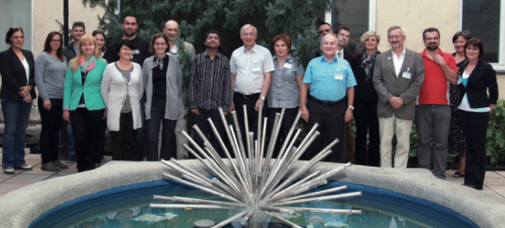
Group photo with University of Zagreb colleagues

zagreb2


The University of Zagreb (http://www.unizg.hr/ ) (established in 1669) is the oldest and biggest university in South-Eastern Europe. It consists of 33 faculties, academies and the Centre for Croatian Studies. With its comprehensive programmes and over 72,000 students it is the strongest teaching institution in Croatia.

The Faculty of Geodesy, University of Zagreb (http://www.geof.unizg.hr ) is a public institution of higher education organizing and carrying out university studies, scientific and highly professional work in the scientific field of geodesy. The Faculty exists, as self-standing institution, since 1962. It is organized in three institutes (Geomatics, Cartography and Photogrammetry, Applied Geodesy), two laboratories (Laboratory for Measurements and Measuring Technology and Open Source Geospatial Laboratory) and the Observatory Hvar. The Faculty is the leading academic institution in geodesy and geoinformatics in Croatia and the region. It offers undergraduate, graduate, doctoral and specialist postgraduate study in geodesy and geoinformatics. Some 500 students are studying at the Faculty.

Dražen Tutić kindly send us the background information and activities of the lab which is summarized below .

Open Source Geospatial Lab (OSGL) was officially established in January 2014 with the goal to follow the mission and vision of the GeoForAll initiative, which we are trying to achieve by better structuring and fostering research, education and professional work in the development and application of open geospatial technologies and geoinformation. Details at http://www.geof.unizg.hr/mod/book/view.php?id=1165

 The Faculty of Geodesy introduced substantial number of geoinformatics courses and modules to the study of geodesy with the introduction of Bologna process in 2005. At first, students and teaching activities were supported by commercial software, but after more than 10 years, majority of teaching and student work is done using open source geospatial technologies such as QGIS, PostgreSQL+PostGIS, GRASS, PROJ4, Mapserver and OpenLayers. Students are also introduced to programming in several programming languages and are encouraged to solve problems by writing their own code.Nevertheless, we think that it is necessary to put more effort into bringing closer the open source technologies to students and teachers, as well as to our partners. So that was the primary activity of OSGL at the beginning.

Screen Shot 2016-09-03 at 18.08.43Screen Shot 2016-09-03 at 18.08.55


Agenda of the OSGL is as follows:

 * to support geospatial research and excellence in education through application of open source tools and data,

* to foster collaboration of Faculty professionals and scientists with national and international professionals and scientists,

* to educate on open source tools and data through study programmes, lifelong learning and other non-formal learning (including e-learning)

* to bring closer related professions and disciplines which can contribute to modern technologies in support spatial decision-making processes.

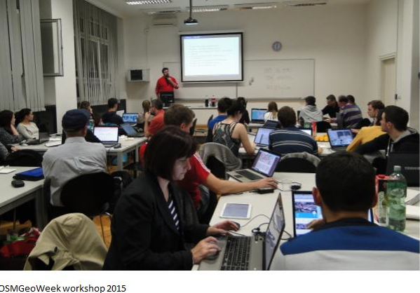
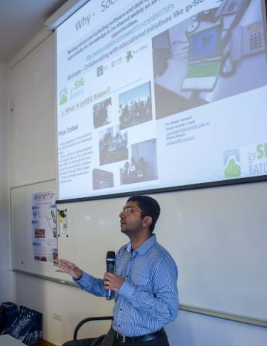
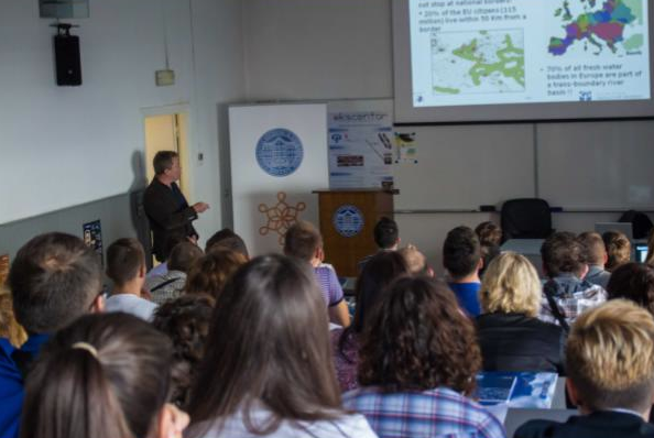
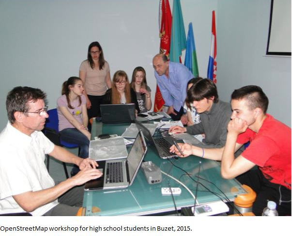
 Among the education materials we can highlight custom training materials for Linux and OSGeo programs published on the e-learning system, and expanded and localised training materials of QGIS GeoAcademy, module 104, Cartography using QGIS for Croatia and Montenegro. In collaboration with Students Council of Faculty of Geodesy and Croatian Cartographic Society we also organize or participate in educational events, e.g. OpenStreetMap Workshops for high school students or Humanitarian OpenStreetMap Team tasks. However, the special notion deserves students seminar Roles of Geodesy and Geoinformation in Sustainable Development where Suchith Anand participated as keynote speaker.

Screen Shot 2016-09-03 at 18.07.45


Screen Shot 2016-09-03 at 18.08.05


Screen Shot 2016-09-03 at 18.08.19

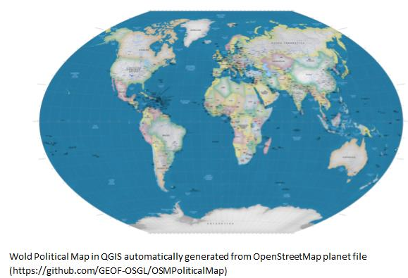
Our open source developing efforts are mainly in the field of our expertise, i.e. cartography and map projections. We are active in PROJ4 project and we published two QGIS plugins (for cartographic line generalisation and visualisation of map projection distortions). Latest project which we found challenging but also rewarding is automatic generation of custom small scale maps from OpenStreetMap data. With an example of automatic generation of wall world political map it has been shown that open data and open technologies can be used for the most challenging tasks in cartography, namely cartographic generalisation. More info on our projects can be found on Github (https://github.com/GEOF-OSGL ).

 Screen Shot 2016-09-03 at 18.09.12

 There is a lot work to be done in the future, especially in capacity building for open source tools and data in Croatia. Joining the GeoForAll initiative made our efforts easier and recognisable, with clear vision for our next steps.”

OSGL Croatia welcomes collaborations from all interested. Please email Dražen at dtutic@geof.hr

We thank Drazen and all colleagues and students at OSGL in Croatia for their contributions to the Geo4All initiative and look forward to working and building more collaborations with all interested on this education mission.

Best wishes,

Suchith Anand

http://www.geoforall.org